
The NZNTT is actively seeking updated information for all trees in the register. If you have information about this tree that we don't currently have recorded, or wish to advise of an inaccuracy please use our information submission form to help us build a complete profile of this tree.
Tree Information x
| Identifier: | AR/1734 |
|---|---|
| Tree Type: | Single |
| Registered By: | Smillie, M.J. |
| Registration Category: | Notable tree/s – Local interest |
| General Notes:
|
In late 1918 and early 1919 General
Paul Pau, a French solider, toured Australia and New Zealand on a post-war diplomatic visit. As part of that visit, he toured the forestry workings in West Auckland, hosting a picnic at Anawhata and witnessing the felling of a large kauri tree [1]. To celebrate this visit, a large tree on Forest Hill Road was named “General Pau” in his honour. That honour lasted only a brief moment, as no reference to the tree by that name has been found past the visit and a photograph from the 1920s [2]. The tree was reasonably well-known, being the subject of a photograph before the General’s visit, and mentioned in a newspaper article nominating this tree and a smaller neighboring tree “near the top of the Forest Hill road…”, along with Clark’s and Bishop’s Kauri in Titirangi (see AR/1443 and AR/1443) as being the closest remaining “big” kauri to Auckland proper [3]. The tree is on private property, and on the Auckland Council’s list of notable trees, but can be glimpsed looking east down into Oratia valley from Forest Hill Road, at the headwaters of Potter Stream (Smillie, M.J., 2021). References [1] “Our French Visitors,” Auckland Star, p. 6, 27 January 1919. [2] W. Beattie, THE GENERAL PAU KAURI, NIHOTUPU. Auckland Libraries Heritage Collections JTD-14F-02126, circa 1920. [3] “Bushman's Craft: Logging at Titirangi,” Auckland Star, p. 8, 9 September 1932. |
Single Tree Details
| Genus: | Agathis | |
|---|---|---|
| Species: | australis | |
| Common names: | kauri, | |
| Given Name: | General Pau | |
| Height: | 32.20m | |
| Height measurement method: | LIDAR | |
| Height Comments: | From 2016-2018 Auckland North Lidar data | |
| Girth: | 786 cm | |
| Girth measurement height: | 2 m | |
| Girth Comments: | Estimated from scaling diameter from old images, not directly measured. | |
| Diameter: | 250.2 cm | |
| Crown Spread A: | 30.00m | |
| Crown Spread B: | 31.00m | |
| Avg. Crown Spread: | 30.50m | |
| Actual Planting Date: | actual date not specified | |
| Approx. Planting Date: |
e.g. circa. 1860 |
|
| Current Age: | not known years | |
| Tree Health Description: | Appears to be in good health via Google Streetview, but may have lost the top branches since the 1920s | |
| Tree Form Type: | Single Trunk | |
| Number of Trunks: | 1 | |
| Tree Form Comments: | Straight bole some 15 m tall. | |
| Champion Tree Score: | 440 | |
| Local Protection Status: | Yes | |
| Tree Present: | Yes | |
| STEM Score: | 0 |
Observations
| Date | Observer | Action |
|---|---|---|
| 21 Mar 2021 | Smillie, M.J. |
Location
|
|||||||||||||||||||||
Images
| Preview | Credit | Date |
|---|---|---|
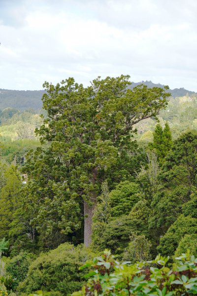 |
Matt Smillie | 02 Apr 2021 |
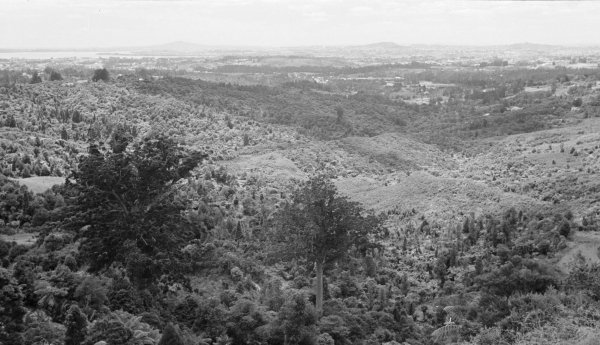 |
J T Diamond Auckland Libraries Heritage Collections JTD-13F-01796 | 01 Nov 1962 |
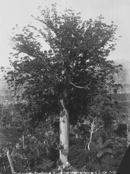 |
William Beattie Auckland Libraries Heritage Collections JTD-14F-02126 | 01 Jan 1920 |
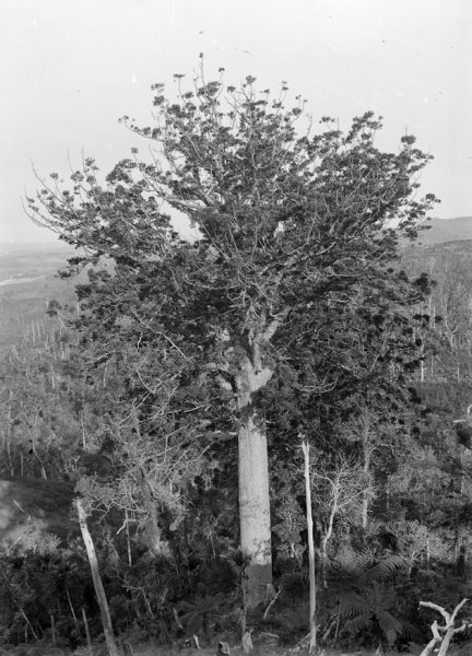 |
James Richardson Auckland Libraries Heritage Collections 4-1535 | 01 Jan 1914 |