The NZNTT is actively seeking updated information for all trees in the register. If you have information about this tree that we don't currently have recorded, or wish to advise of an inaccuracy please use our information submission form to help us build a complete profile of this tree.
It has been more than ten years since we recorded a measurement for this tree. If you are able to provide us with new measurements please fill out the information submission form for this tree.
Tree Information x
| Identifier: | NR/1376 |
|---|---|
| Tree Type: | Single |
| Registered By: | Smillie, M.J. |
| Registration Category: | Historic tree – National interest |
| General Notes: |
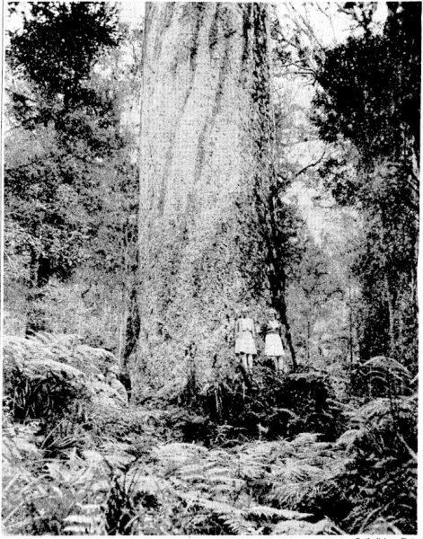
Omahuta Forest was logged from the 1880’s until the middle of the 20th century, with wind thrown trees removed for their timber after a cyclone in 1959[1]. Eight years earlier a small 6 ha sanctuary of exceptional trees was created, with the largest given the name “Kopi”, after the New Zealand Forest Service officer in charge at the time, a Mr Corby[2]. Kopi was the largest tree in the sanctuary and considered by many to be the best kauri tree by combination of girth, height of bole and overall height. At 212 cubic metres total merchantable volume, it was ranked the third largest kauri in 1971 after Toronui (NR/0805) and Tane Mahuta (NR/0800) and ahead of Te Matua Ngahere (NR/0802).
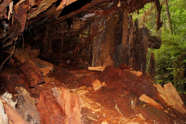
In 1973 a storm felled the tree, revealing it to be hollow inside, a literal shell of its outer size and splendor. A colony of lesser short-tailed bats (Mystacina tuberculata) or pekapeka-tou-poto was found living inside. The fallen log can be seen as of 2016, although almost unrecognisable, so obscured is it by regrowth, at the intersection of the loop track around the sanctuary and the short spur track leading to the Hokianga tree (NR/0803). Some images of the tree, taken before it fell can be seen at the Auckland Library website, and an account of a visit soon after it fell is here. The stated height of the tree of 56.7 m (186 ft) is probably an over-estimation due to the limitations of the methods of the time of measurement in 1971. Other trees in the sanctuary, and other large Kauri tend to have shorter heights than the official NZFS measurements from 1971. An account of the tree in Reed[3] describes the crown spread as "6210 ft…somewhat less than Tane Mahuta”. A circular crown area of 6210 square feet corresponds to an average crown spread of 27 m, indeed "somewhat less than" Tane Mahuta’s 38 m. (Smillie, 2016) [1] E. V. Sale, The Quest for the Kauri, Reed, 1978. [2] S. W. Burstall, “Historic and Notable Trees Northland and Auckland, Mensuration Report No. 16 (Unpublished),” 1971. [3] A. W. Reed, The New Story of the Kauri, 1964. |
Single Tree Details
| Genus: | Agathis | |
|---|---|---|
| Species: | australis | |
| Common names: | kauri, | |
| Given Name: | Kopi | |
| Height: | 56.70m | |
| Height measurement method: | Unknown | |
| Height Comments: | Abney levels and hyposometers were typically used at the time of measurement, but could be inaccurate on the large spreading crowns of kauri. | |
| Girth: | 1318 cm | |
| Girth measurement height: | 1.37 m | |
| Girth Comments: | Height taken "above stump" | |
| Diameter: | 419.5 cm | |
| Crown Spread A: | 27.00m | |
| Crown Spread B: | 27.00m | |
| Avg. Crown Spread: | 27.00m | |
| Actual Planting Date: | actual date not specified | |
| Approx. Planting Date: |
e.g. circa. 1860 |
|
| Current Age: | not known years | |
| Tree Health Description: | Hollow at time of falling. | |
| Tree Form Type: | Single Trunk | |
| Number of Trunks: | 1 | |
| Tree Form Comments: | 16.7 m bole. | |
| Champion Tree Score: | 727 | |
| Local Protection Status: | Yes | |
| Tree Present: | No | |
| STEM Score: | 0 |
Observations
| Date | Observer | Action |
|---|---|---|
| 01 Jan 1971 | Burstall, S.W. |
Location
|
|||||||||||||||||||||
Images
| Preview | Credit | Date |
|---|---|---|
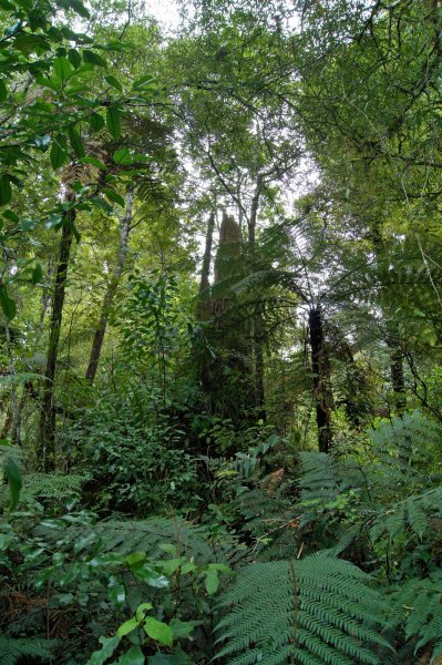 |
Matt Smillie | 23 Apr 2016 |
 |
Matt Smillie | 23 Apr 2016 |
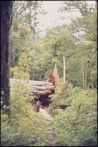 |
John Burgess, Auckland Libraries Heritage Collections 1528-74015, CC BY-NC | 01 Jan 1974 |
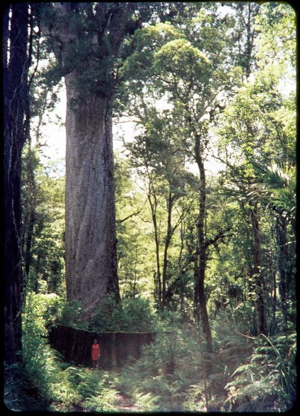 |
John Burgess, Auckland Libraries Heritage Collections 1528-69075A, CC BY-NC | 01 Jan 1969 |
 |
Evening Post, Volume CXXVII, Issue 122, 26 May 1939, Page 7 | 26 May 1939 |