The NZNTT is actively seeking updated information for all trees in the register. If you have information about this tree that we don't currently have recorded, or wish to advise of an inaccuracy please use our information submission form to help us build a complete profile of this tree.
It has been more than ten years since we recorded a measurement for this tree. If you are able to provide us with new measurements please fill out the information submission form for this tree.
Tree Information x
| Identifier: | NR/0803 |
|---|---|
| Tree Type: | Single |
| Registered By: | Cadwallader, B.G. |
| Registration Category: | Notable tree – National interest |
| General Notes: |
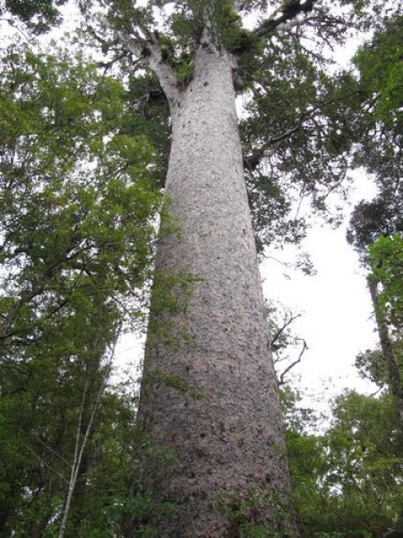
Located in Omahuta Forest, 'Hokianga' has in the past been considered the tallest giant kauri in Northland (Burstall & Sale 1984). Formerly recorded at 53.3m it was laser measured in 2009 at 47.2 m by USA tree researcher, Robert Van Pelt. Another unnamed tree, located nearby, was found to have a height of 51.6 m. (NZ Summary sheet, BVP April 2009)
Hokianga is named after the harbour whose headwater lie only a few kilometres to the west, which gains its name from one of the great historical traditions of the Maori people. The harbour name is shortened from Te Hokianga a Kupe, which means "the returning of Kupe", thus marking the place from which the great ancestral navigator Kupe who first explored New Zealand returned to his ancestral home in Hawaiki (Burstall & Sale 1984). |
Single Tree Details
| Genus: | Agathis | |
|---|---|---|
| Species: | australis | |
| Common names: | kauri, | |
| Given Name: | 'Hokianga' | |
| Height: | 47.20m | |
| Height measurement method: | Laser Impulse 200 LR | |
| Height Comments: | (none) | |
| Girth: | 1001.5 cm | |
| Girth measurement height: | 1.65 m | |
| Girth Comments: | (none) | |
| Diameter: | 318.8 cm | |
| Crown Spread A: | 30.20m | |
| Crown Spread B: | 30.20m | |
| Avg. Crown Spread: | 30.20m | |
| Actual Planting Date: | actual date not specified | |
| Approx. Planting Date: |
e.g. circa. 1860 |
|
| Current Age: | not known years | |
| Tree Health Description: | (none) | |
| Tree Form Type: | Single Trunk | |
| Number of Trunks: | 1 | |
| Tree Form Comments: | (none) | |
| Champion Tree Score: | 574 | |
| Local Protection Status: | Unknown | |
| Tree Present: | Yes | |
| STEM Score: | 0 |
Observations
| Date | Observer | Action |
|---|---|---|
| 25 Mar 2009 | Van Pelt, R. |
Location
|
|||||||||||||||||||||
Images
| Preview | Credit | Date |
|---|---|---|
 |
NZFrenzyGuideBook | 22 Feb 2011 |
 |
NZFrenzyGuideBook | 22 Feb 2011 |